FactLook.com was recently hired to produce a thematic map showing which of the US states had individuals on death row who claim Native American as their race. We found the data needed to build the map at DeathPenaltyInfo.org. The largest number of Native Americans on death row were incarcerated in California, which has the largest […]
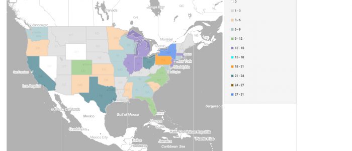
Map of the Day: 070516 – High School Tennis Participation by State
On this day in 1975, Arthur Ashe defeated Jimmy Connors to become the first African American tennis player to win Wimbledon. Connors was heavily favored but fell to Ashe’s strategy of only giving Connors “junk” to hit. Ashe won the match 6-1, 6-1, 5-7, 6-4. FactLook was curious to see which state might produce the […]
Map of the Day: 070116 – Reported Fireworks Injuries, Washington, Counties (2015)
Independence Day can turn into a very bad day for those who are injured by fireworks. We looked at Washington to get an idea of the number of reported fireworks injuries: the state’s fire marshall maintains an annually updated database of incidents reported by the state’s EMS and hospitals. As would be expected, the largest concentration […]
Map of the Day: 063016 Chicago Homicides and Foreign Born Pop. Not Citizens by Congressional District
FactLook was recently hired to produce a thematic map displaying the location of homicides in Chicago in comparison to the concentration of the city’s foreign born population who are not US citizens. We found the latter data using the US Census Bureau’s American Fact Finder service and obtained the homicide info from the City of […]
3-Minute Challenge: Two Datasets and 500 Geocoded Locations
We wanted to show how much you can do with FactLook.com for less … less time, less money and less hassle. So we gave ourselves the challenge of building a map showing two metrics: the number of Foreign Born Individuals, Not US Citizens in Congressional Districts in Illinois and the location of 500 homicides in […]
Map of the Day: 062916 – Home states of US Astronauts
On this day in 1995, the US space shuttle successfully docked with Russia’s MIR space station. While docked, the craft and station formed the largest man-made satellite to orbit the earth. This event led to future cooperation between the two countries, paving the way for the development of the International Space Station. We were curious to […]
Map of the Day: Chevrolet Corvette Registrations by State
To celebrate the 63rd anniversary of the production of the first Chevy Corvette, we wanted to see the distribution of these American icons across the US. Our search for the data led us to The Corvette Action Center website which had stats for the year 2009 — not as current as we’d like but […]
Map of the Day: Day Care Centers and Children Age 3 under by census tract, Marin Co., CA
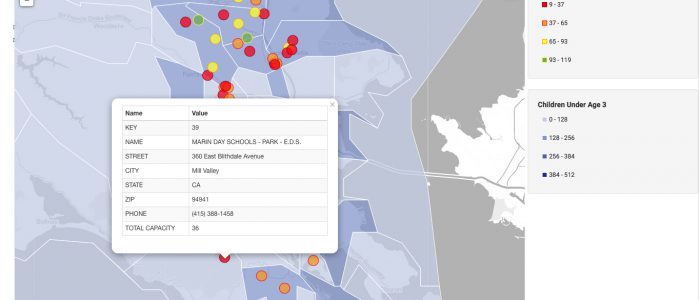
FactLook was asked by a client to create a map showing the location of several day care centers in Marin Co., California. We went one better by adding demographics about the number of day care aged kids for those same areas from the US Census Bureau. We began building this map by creating a layer (blue […]
Map of the Day: Most UFO Sightings by state
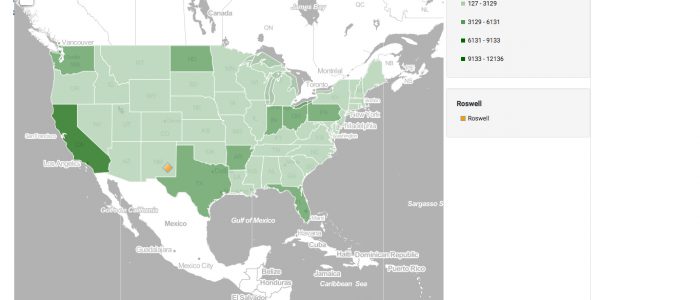
On June 24, 1997 U.S. Air Force officials released a 200+ page report on the crash of an unidentified object outside Roswell, New Mexico in July, 1947. From History.com: “Titled “The Roswell Report, Case Closed,” the document stated definitively that there was no Pentagon evidence that any kind of life form was found in the […]
Map of the Day: New Jersey Mall Sales, 2012, by select counties … and Tiffany!
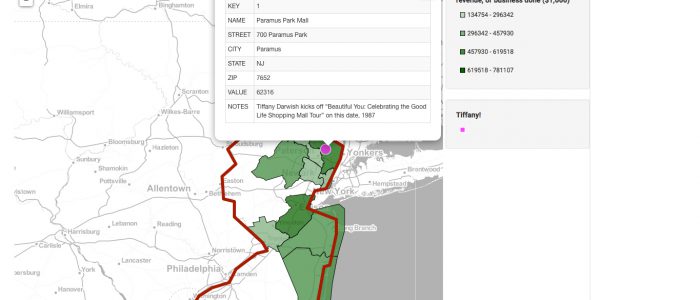
On this day, courtesy of History.com: “A 16-year-old aspiring pop star named Tiffany Darwish had a self-titled debut album on a major record label that was gathering dust on record store shelves around the country. What transformed Tiffany the album into a quadruple-Platinum smash hit and Tiffany the singer from a flop into a pop idol was a […]