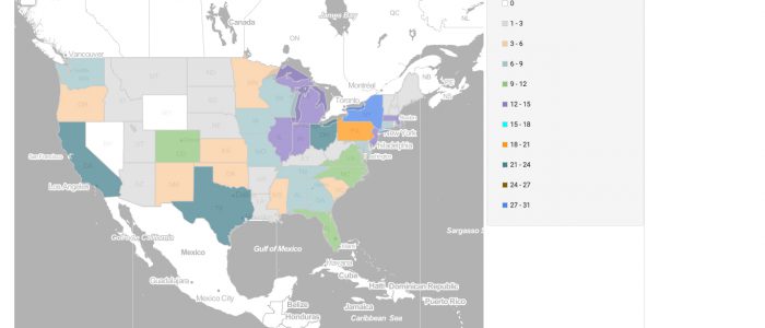
FactLook was recently hired to produce a thematic map displaying the location of homicides in Chicago in comparison to the concentration of the city’s foreign born population who are not US citizens. We found the latter data using the US Census Bureau’s American Fact Finder service and obtained the homicide info from the City of […]
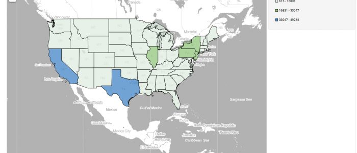
3-Minute Challenge: Two Datasets and 500 Geocoded Locations
We wanted to show how much you can do with FactLook.com for less … less time, less money and less hassle. So we gave ourselves the challenge of building a map showing two metrics: the number of Foreign Born Individuals, Not US Citizens in Congressional Districts in Illinois and the location of 500 homicides in […]
Map of the Day: 062916 – Home states of US Astronauts
On this day in 1995, the US space shuttle successfully docked with Russia’s MIR space station. While docked, the craft and station formed the largest man-made satellite to orbit the earth. This event led to future cooperation between the two countries, paving the way for the development of the International Space Station. We were curious to […]
Map of the Day: Chevrolet Corvette Registrations by State
To celebrate the 63rd anniversary of the production of the first Chevy Corvette, we wanted to see the distribution of these American icons across the US. Our search for the data led us to The Corvette Action Center website which had stats for the year 2009 — not as current as we’d like but […]
Map of the Day: Day Care Centers and Children Age 3 under by census tract, Marin Co., CA
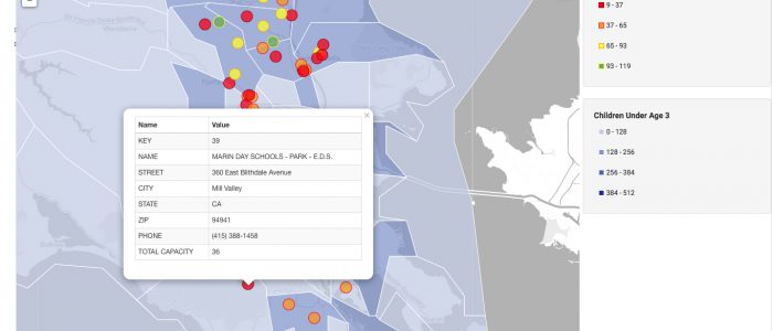
FactLook was asked by a client to create a map showing the location of several day care centers in Marin Co., California. We went one better by adding demographics about the number of day care aged kids for those same areas from the US Census Bureau. We began building this map by creating a layer (blue […]
Map of the Day: Most UFO Sightings by state
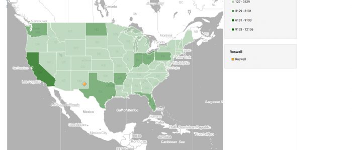
On June 24, 1997 U.S. Air Force officials released a 200+ page report on the crash of an unidentified object outside Roswell, New Mexico in July, 1947. From History.com: “Titled “The Roswell Report, Case Closed,” the document stated definitively that there was no Pentagon evidence that any kind of life form was found in the […]
Map of the Day: New Jersey Mall Sales, 2012, by select counties … and Tiffany!
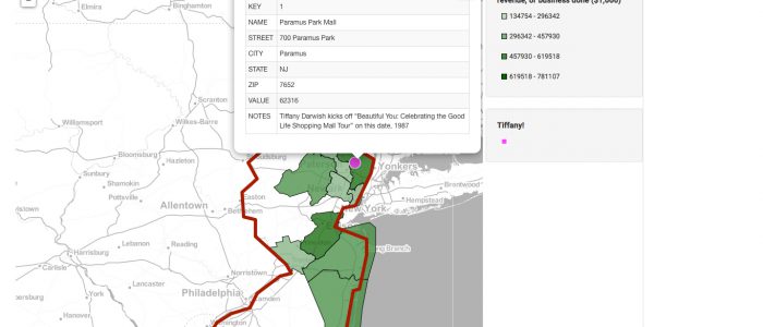
On this day, courtesy of History.com: “A 16-year-old aspiring pop star named Tiffany Darwish had a self-titled debut album on a major record label that was gathering dust on record store shelves around the country. What transformed Tiffany the album into a quadruple-Platinum smash hit and Tiffany the singer from a flop into a pop idol was a […]
Map of the Day: US High School Soccer Programs and Participants
Today marks the 30th anniversary of Argentina’s victory over England in World Cup play, a victory assisted in part by Argentinian superstar Diego Madonna’s celebrated “Hand of God” goal. These two maps show the number of US high schools with soccer programs by state and the number of participants in those programs during the 2014-2015 completion season. […]
Map of the Day: Active KKK Chapters in Mississippi
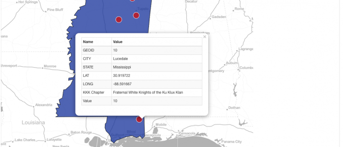
On June 21, 1964, three civil rights field workers went missing in Neshoba County in central Mississippi. It was later determined that Michael Schwerner, Andrew Goodman and James Chaney had been killed by members of the Ku Klux Klan. The disappearance and murder of the three Congress of Racial Equality (CORE) workers drew national attention […]
Map of the Day: Washington county map displaying median household income and percentage of population 18+ who are Veterans
This map displays two county-level metrics for the state of Washington: median household income (blue shades) and the percentage of the population 18+ who are Veterans (red shade dots). We chose to use FactLook’s geocoding feature (Location: Street Address) to place markers at each county’s courthouse address and tied the population percentage data to these markers. The […]