We used FactLook to combine two datasets — the population of Marin County, California by census tract and a list of historic sites provided by the County of Marin.
MOTD: 102016 Firms Started in US with Personal Credit Card as Source of Capital (2014)
If you were starting business in 2014 and needed financing, there was a decent chance you reached for your personal credit card to get the business rolling. Using data from the US Census Bureau, we plotted the percentage of firms by state for which personal credit card was used as the source of funding to […]
MOTD: 101316 Florida Public Libraries and Pop. Per Sq. Mile
We used publicly accessible data to visualize the distribution of public libraries in Florida along with the population per square mile per county. Want to build geography-based data visualizations like this? Visit FactLook.com to start a free trial.
MOTD: 101116 Location of Cell Towers in Florida
Need a stronger cell signal in Florida? We were curious about the location and distribution of cell towers across the state and found that data via the U.S. Department of Homeland Security’s Homeland Infrastructure Foundation-Level Data site. We started out creating a data viz showing the population per square mile for Florida by county. We […]
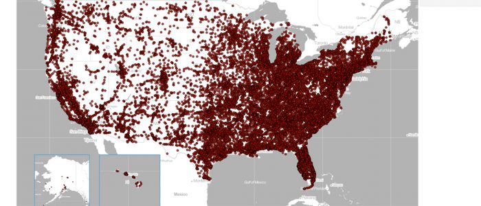
MOTD: 100716 – McFarthest Point
A FactLook user recently sent us the following data viz showing the location of all McDonald’s restaurants in the U.S. in order to determine the location of the “McFarthest Point” — the spot in the U.S. that’s most remote from a Mickey Dees. He notes: I wanted to determine the “McFarthest Point” in the lower […]
MOTD: 100516 Hurricane Shelter Locations for Miami-Dade County, FL
Hurricane Matthew is expected to arrive in the Miami area Thursday afternoon. The powerful category 4 storm was carrying maximum sustained winds of 130 mph as it approached Cuba on Tuesday evening. This is a storm we hope all in Matthew’s path take seriously and seek shelter from. We pulled housing demographic data by ZIP […]
MOTD: 100316 — Hispanic Share of Eligible Voters in Colorado
According to the Pew Research Center, 27.3 million Latinos will be eligible to vote in the 2016 presidential election. We wanted to look at a few “swing states” where the Latino vote could have the biggest impact on the election. First up, Colorado. We used the PRC’s data to to create this data viz showing the […]
MOTD: 092716 – Pop. Claiming German Ancestry in St. Louis area by ZIP
The leaves are turning and the kegs are tapped — it can only mean one thing. Oktoberfest season has arrived! We were curious where some of the best “Fests” would be which led us to wonder which communities have some of the largest German populations. We landed on St. Louis. Pulling data from the US Census Bureau’s American […]
MOTD: 092316 — US Auto Accident Fatalities 2015
The US Department of Transportation’s National HighwayTraffic Safety Administration maintains a nationwide census of fatal injuries suffered in motor vehicle traffic crashes. The Fatality Analysis Reporting System (FARS) can be accessed here. Using the FARS data and FactLook’s geocoding feature, we plotted every auto accident by the number of fatalities. The first data viz we created is for […]
MOTD: 092116 Percentage of KY Population Physically Inactive (2016)
Physical Inactivity is one of the measures health agency’s use in factoring a demographics overall wellness. The County Health Rankings & Roadmaps tracks numerous measures on a county basis, including physical inactivity. The CHRR data is for the percentage of adults aged 20 and over reporting no leisure-time physical activity. What are the health consequences of being […]